Creation of a map based PLOG
As well as permitting you to create PLOGS via a menu based system, Pilot Plan will also allow you to create PLOGS by dropping waypoints directly on to the map. This is often much easier, especially as you can see controlled airspace on the map - it lets you undertstand if you journey or legs will cross CAS and therefore what other planning might be required (clearances, radio etc).
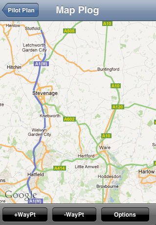
| From Pilot Plan's main menu, choose "Create Map Based PLOG" and you will see a map view. (Note: your device needs an internet connection in order for this feature to work. If Pilot Plan seems to "hang" or "pause" when you choose "Create Map Based PLOG", check you've got a good signal first) From here you can add / remove waypoints and save the PLOG for emailing and printing. |
Adding waypoints
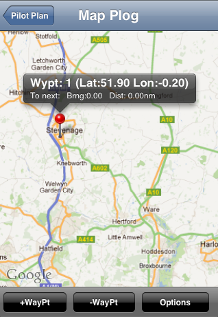
Fig 1
| 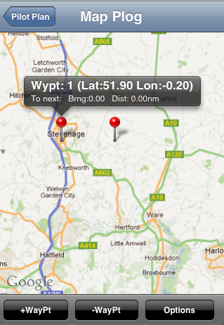
Fig 2
| 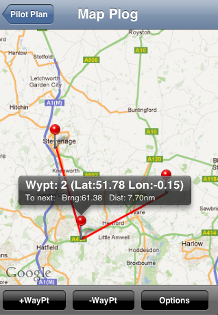
Fig 3
|
HIt "+Waypt" and a red pin is dropped onto the map
Tap it once to see details about it - note that its "To Next Brng(bearing) and Dist" values in the information bubble are zero because no other waypoints exist (Fig 1). Hit "+Waypt" again and another red pin appear to the right of the original pin (Fig 2).
Drag the second pin to somewhere else and note that Pilot plan joins the two pins with the leg (red line).
HINT To "drag" a pin around follow this procedure;
1. Just tap and let go of the pin you want to move, so its information bubble pops up (this means you've "selected" it)
2. Then, press and hold on the same pin and don't let go - whilst keeping your finger down on the screen, drag the pin to the desired location.
Remember to: select the pin once by tapping it and then press and hold the pin to drag it.
Keep adding waypoints and dragging them around until you've created a journey. Each time you add or move a pin around, Pilot Plan cycles through each pin on the map, updating it's Bearning and distance to the next pin.
NOTE: Sometimes when you add or drag a pin around, the pin itself (or another pin) may seem to "jump" away from the red journey line and the correct location, giving the illusion the pin(s) has moved out of alignment. This is just a rendering glitch - pinch to zoom in/out slightly and the errant pin(s) will jump straight back to their correct locations. It doesn't affect the Lat/Lon calculations or the maths Pilot Plan performs. Just zoom the map slightly to force it to refresh and the pins will all move to their correct locations.
Removing waypoints
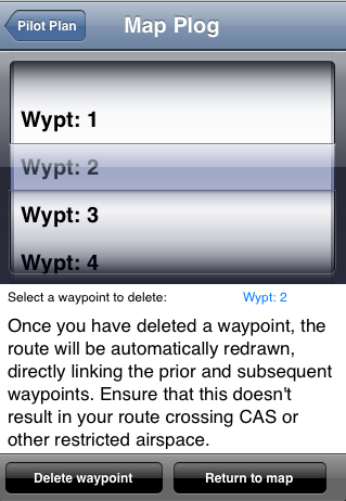
| To remove a waypoint, simply hit "-Waypt" and choose the one you want to delete.
Note that the preceeding and following pins will then be joined up directly automatically. |
Saving the PLOG
| To save the PLOG, hit OPTIONS and then enter a plog name and hit SAVE.
At this point, you could either email the PLOG directly using the EMail plog function described under "PLOGs" link at top or (more likely) you will want to edit the names of the waypoints etc first. Just return to the main menu and select "Create/Edit existing PLOG" and load the plog you've created into the table. Then, you can edit the various entries in the table as normal and email onwards once done. Note that PLOGs you've created in the Map can be loaded back into the map (even after you've edited the plog in "table" mode) but note that PLOGs that were created natively in the table mode cannot ever be loaded into the map because the waypoints contain no Lat / Lon information. |
Display CAS (Controlled Airspace)
Pilot Plan can display airspace files based on Tim Newport-Peace's Special Use Airspace Format.
To display airspace for a choosen country, follow the steps below;
To display airspace for a choosen country, follow the steps below;
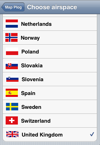
Fig 1
| 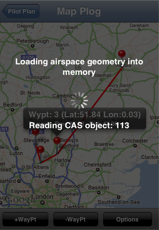
Fig 2
| 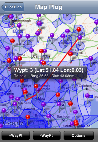
Fig 3
|
Go to the map view via "Create Map Based PLOG" from the main menu.
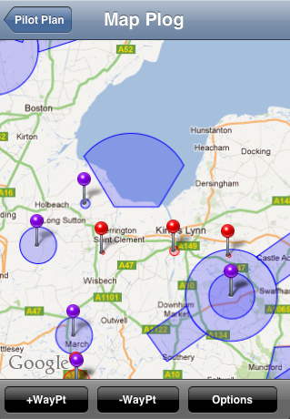
Hit OPTIONS and select "Choose airspace file to display". Select the country you want to display (Fig1) and then hit "Map Plog" at the top of the country menu to return to the OPTIONS menu.
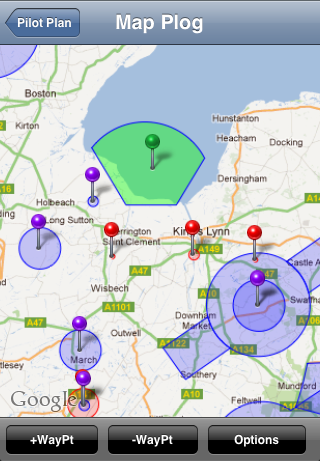
Now hit "Update airspace on map for selected country" and be patient whilst Pilot Plan draws the airspace (which can take some time based on the size of the country you've selected and the complexity of its airspace). (Fig 2)
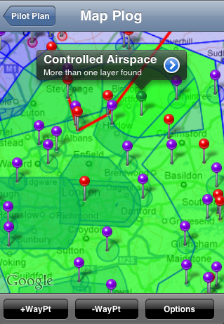
Once complete, you will see something similar to Fig 3. You can tap any of the pins to see a description of that part of CAS - this includes things like danger areas, CTRs, ATZ's, restricted areas etc. It may help you to find your home airport and surrounding CAS first to understand how Pilot Plan displays information before you start examining other areas of CAS in your country or CAS in other countries.
Whilst Pilot Plan draws all the airpsace (blue shaded areas) it doesn't necessarily add a pin for every piece of airspace immediately (the map would be unusable). Instead, you can select the shaded areas for further analysis.
| 
| 
| In this example, we've zoomed into the Holbeach danger area in the UK.
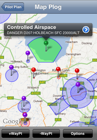
If you now double tap the blue area, it changes from blue to green and a green pin appears. Tap the green pin and the information bubble then tells you what the CAS respresents. |
| 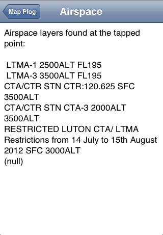
| Of couse, given the 3d nature of airspace, it's likely that if you double tap a more complex part of the world, many layers can exist.
If this happens, the information bubble will tell you. Tap the blue arrow in the bubble and the various layers of CAS found under the Pin will be listed. Try browsing around the LTMA area of the UK and you will appreciate just how complex airspace can be. |
Useful hints
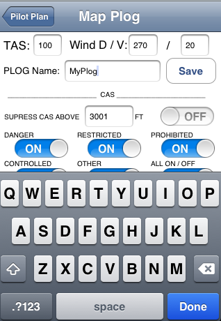
Go to the options menu and switch off certain types of airspace if required using the toggle buttons. This can de-clutter the map and make it easier to understand / browse.
Also, you can avoid displaying airspace above a certain base altitude (eg 5000 feet). If you are planning your journey to be conducted below a certain altitude, switch off the CAS above your intended altitude by entering it into the OPTIONS screen under "Suppress CAS ABOVE XXXX feet". This will greatly simplify the map by removing irrelevant airspace that will exist high above you.
Also, you can avoid displaying airspace above a certain base altitude (eg 5000 feet). If you are planning your journey to be conducted below a certain altitude, switch off the CAS above your intended altitude by entering it into the OPTIONS screen under "Suppress CAS ABOVE XXXX feet". This will greatly simplify the map by removing irrelevant airspace that will exist high above you.
Can I create my own airspace files?
As mentioned above , Pilot Plan uses data files based on Tim Newport-Peace's Special Use Airspace Format.
Visit here: http://soaringweb.org/Airspace/ and follow the various links to understand how airspace files work / are created etc.
If you create an airspace file and wish to have it included in the next version of Pilot Plan, submit a comment / suggestion on the home page of this site http://pilotplan.weebly.com/index.html and I can include your airspace file in the next version of the app.
