Important! Read this first!
Pre-flight planning is very important - you must ensure you complete a proper pre-flight planning process before each and every flight. DO NOT RELY ON PILOT PLAN TO DO THIS! You should always double check any calculations yourself, manually, that Pilot Plan makes.
Always seek advice from a qualified pilot / instructor if you are at all unsure of any particular point. If you make a mistake, you (and your passengers) will suffer dire consequences.
Pilot Plan is not to be used for operational purposes. It is solely the user's responsibility to ensure that they have accurate flight planning information.
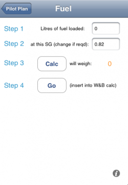 | FuelEnter the litres of fuel loaded onto the aircraft. This should be the total absolute amount (Pilot Plan deals with unusable and reserve fuel in a later step).
Just ensure that the total amount in the aircraft's tanks = what you've entered here. Then enter the specific gravity of the fuel you have loaded. AvGas is different to Jet A1 so double check the SG for your fuel. Technically, you should also temperature adjust to arrive at the true SG but given the relatively small amount of fuel that most light aircraft are loaded with, this isn't likely to adversely affect the calculated weight and balance of the aircraft. Once you've entererd the litres of fuel loaded, hit CALC. This will then give you the weight (KG) of the fuel loaded. Pilot Plan will use these values for Weight & Balance calculations as well as range calculations in later steps. Finally, hit GO to move onto Weight & Balance. |
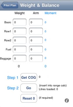 | Weight & BalanceEnter the various weights and their moment arms as appropriate. Fuel weight is entered for you already if you are following on from the previous step.
You can get these values from your aircraft's balance schedule. At the very least, you will need the basic weight, row 1 (you + co-pilot / passenger) and fuel. Leave entries not required as 0 (zero). Hit GET COG and Pilot Plan works out the total mass (bold number at bottom of WEIGHT column) and the centre of gravity. Make sure that; A) Total weight is less than MTOM (maximum take off weight) B) the COG is within the weight and balance envelope of your aircraft by checking both the calculated numbers back to your aircraft schedule. If you are over MTOM or are nose or tail heavy, "Bad Things" will happen to you and the aircraft as soon as you get airborne. Type this into a well known search engine: weight balance accident loading To see what happens if you don't get this right (basically, you'll probably die). Hit GO in Step 2 to be taken to the range calculation step. |
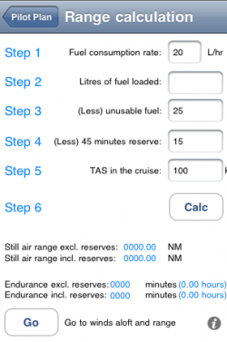 | Range CalculationPilot Plan inserts typical values for a light aircraft when you reach this step and also inserts the litres of fuel loaded from 'FUEL' step earlier (if you've been following the steps as appropriate).
Either way, double check the values shown and change them as necessary to reflect your aircraft. Once you hit CALC, Pilot Plan works out the still air range of your aircraft with reserves and without reserves. Pilot Plan also works out your aircraft's endurance (how long the engine(s) will run before they run out of fuel) whilst in the cruise. Note that fuel for manoeuvring / flying in circles in the pattern waiting for a free approach to the R/W is not accounted for. If you want to add more fuel for this, simply increase the amount of 'reserve' fuel and Pilot Plan will decrease your range as appropriate. Hit GO to move onto the next step once you are satisfied. (Remember to hit CALC before moving on otherwise a previous old calculated value could be used accidentally) |
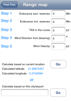 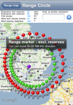 | Range MapIf you arrived at this step from the previous step, then endurance and TAS (true airspeed) are entered for you.
Simply enter the wind aloft direction and velocity for your planned cruise altitude. (eg 240 degrees, 20Kts) Now, if your iPhone / pod / pad / whatever can get a GPS lock (A-GPS is good enough) and ALSO has an internet connection (either via 3g, Edge, GPRS or Wifi) then you can hit the GO button next to "Calculate Based on current Location". Otherwise, if no GPS is available, you'll have to type in the name of your airport manually underneath and hit the second GO button. Either way, Pilot Plan then draws a couple of pretty circles around your current location on a map. The inner green circle of pins indicates the range your aircraft can manage based on usable fuel less reserves. The red circle of pins indicates how far the aircraft will eventually go before your engine(s) will stop. Note that both circles are "deformed" and adjusted for the wind aloft you entered earlier. Thus, with a southwesterly wind as in this example, the range "into wind" is clearly less then when flying to the North-East (with a tail wind). You can hit the back button at the top of the map ("Range Map"), fiddle with the wind speed / velocity values and see the (remarkable) effect this has on your aircraft's true range. This is because in general, light aircraft fly relatively slowly compared to larger aircraft cruising at 100~120kts TAS usually. A wind aloft of e.g. 20kts is therefore 20%~25% of the aircraft's speed - this means any wind usually has a significant effect on where you can go in a light aircraft on any particular day, assuming you wish to use the aircraft's effective range fully. Larger, heavier duty aircraft fly at speeds in excess of 400kts which means winds aloft affect them less (but do still affect them) because wind velocity as a percentage of aircraft speed is less. Note you can tap any pin to get a value based readout of the true NM the aircraft can fly in that direction. Also, you can enter another city / airport at top of the screen, hit the + symbol and Pilot Plan will redraw the circles at your chosen location. You can then zoom out from the map (normal iphone pinch zoom method) and you can compare the range circles in different parts of the world. |
